The principle climate of Minnesota in punctuated by two primary seasons. The winter and summer seasons of Minnesota are influenced by two to three main air masses. In the Summer continental polar fronts will make hot, unbearably humid days drier and more mild. The warm air masses come from the south and travel upwards from the Gulf of Mexico constituting a maritime tropic airmass. In the winter as the jet stream descends towards the lower latitudes in the United States the continental polar air mass reaches farther down contributing to the dominant temperature and weather in Minnesota.
 |
| The Jet stream during the winter and summer. Photo courtesy of nc-climate.ncsu.edu |
 |
| The air masses of North America. Photo courtesy of www.fas.org |
During the summer months and especially in July, interactions between the cool, dry continental polar air masses and the warm, wet maritime tropical air masses from the gulf collide to create an active thunderstorm season. In the summer, when the jet stream hovers near the latitude of central Minnesota warm and cold fronts converge and create strong areas of low pressure which fuel thunderstorms and even tornadoes. While I lived in Minnesota I can recall countless tornado warnings that urged people to seek shelter and stay indoors. I had personally never encountered a tornado within a dangerous proximity but the danger always seemed quite real. The video below offers what it was like as a child experiencing tornado season first hand.
When the southern and northern airmasses occlude the occlusion takes place as a cold occlusion as the cold air mass will typically be colder then the air mass in front of it. As the cold air mass pushes the warm air mass above it clouds form and precipitation may take place.
There are some factors that are unique to my area. Though not in the immediate vicinity, northern Minnesota, which is very close to Lake Superior experiences weather similar to what one might expect in a maritime environment.
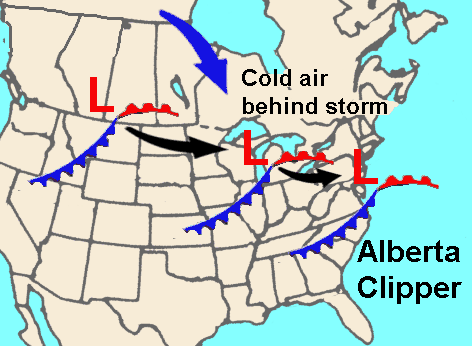
With relatively warmer weather than the rest of Minnesota in the winter and cooler weather in the summer, northeast Minnesota has a very unique climate. Additionally, phenomenon similar to how the chinook winds work in the Rockies, the Coteau des Prarie can warm cities to the north. In the winter months Alberta clippers, which are fast moving areas of low pressure blow through the region bringing different sorts of weather patterns with them that contribute to the snow storms with them. Panhandle hooks also make their way to Minnesota which act as areas of low pressure originating from the southwest.
Sources:
- Keen, Richard (1992). Minnesota Weather. American and World Geographic Publishing.
- Palmer, Chad. "Alberta Clippers reinforce cold air". USA Today. http://www.usatoday.com/weather/tg/wclipper/wclipper.htm
- USA Today -> http://usatoday30.usatoday.com/weather/tg/wamsorce/wamsorce.htm
- "Lake Superior Uplands". Minnesota DNR. http://www.dnr.state.mn.us/ecs/212Lb/index.html.
 |
| Alberta Clipper. Photo courtesy of wx-man.com |
Sources:
- Keen, Richard (1992). Minnesota Weather. American and World Geographic Publishing.
- Palmer, Chad. "Alberta Clippers reinforce cold air". USA Today. http://www.usatoday.com/weather/tg/wclipper/wclipper.htm
- USA Today -> http://usatoday30.usatoday.com/weather/tg/wamsorce/wamsorce.htm
- "Lake Superior Uplands". Minnesota DNR. http://www.dnr.state.mn.us/ecs/212Lb/index.html.
No comments:
Post a Comment