Friday, November 16, 2012

Air and Cyclones


The principle climate of Minnesota in punctuated by two primary seasons. The winter and summer seasons of Minnesota are influenced by two to three main air masses. In the Summer continental polar fronts will make hot, unbearably humid days drier and more mild. The warm air masses come from the south and travel upwards from the Gulf of Mexico constituting a maritime tropic airmass. In the winter as the jet stream descends towards the lower latitudes in the United States the continental polar air mass reaches farther down contributing to the dominant temperature and weather in Minnesota. 


The Jet stream during the winter and summer. Photo courtesy of nc-climate.ncsu.edu


The air masses of North America. Photo courtesy of www.fas.org


During the summer months and especially in July, interactions between the cool, dry continental polar air masses and the warm, wet maritime tropical air masses from the gulf collide to create an active thunderstorm season. In the summer, when the jet stream hovers near the latitude of central Minnesota warm and cold fronts converge and create strong areas of low pressure which fuel thunderstorms and even tornadoes. While I lived in Minnesota I can recall countless tornado warnings that urged people to seek shelter and stay indoors. I had personally never encountered a tornado within a dangerous proximity but the danger always seemed quite real. The video below offers what it was like as a child experiencing tornado season first hand. 


When the southern and northern airmasses occlude the occlusion takes place as a cold occlusion as the cold air mass will typically be colder then the air mass in front of it. As the cold air mass pushes the warm air mass above it clouds form and precipitation may take place. 

There are some factors that are unique to my area. Though not in the immediate vicinity, northern Minnesota, which is very close to Lake Superior experiences weather similar to what one might expect in a maritime environment. 

With relatively warmer weather than the rest of Minnesota in the winter and cooler weather in the summer, northeast Minnesota has a very unique climate. Additionally, phenomenon similar to how the chinook winds work in the Rockies, the Coteau des Prarie can warm cities to the north. In the winter months Alberta clippers, which are fast moving areas of low pressure blow through the region bringing different sorts of weather patterns with them that contribute to the snow storms with them. Panhandle hooks also make their way to Minnesota which act as areas of low pressure originating from the southwest. 

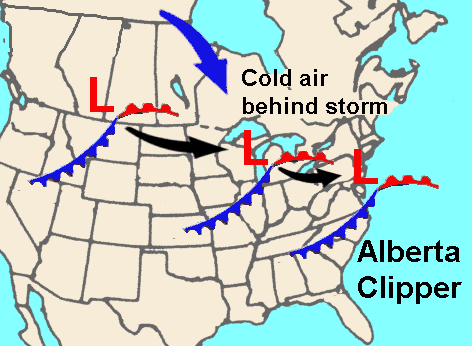
Alberta Clipper. Photo courtesy of wx-man.com


Sources:
Keen, Richard (1992). Minnesota Weather. American and World Geographic Publishing.
Palmer, Chad. "Alberta Clippers reinforce cold air". USA Today. http://www.usatoday.com/weather/tg/wclipper/wclipper.htm
- USA Today -> http://usatoday30.usatoday.com/weather/tg/wamsorce/wamsorce.htm
"Lake Superior Uplands". Minnesota DNR. http://www.dnr.state.mn.us/ecs/212Lb/index.html.

Tuesday, October 23, 2012

Weather Station by Sam Epperly

The weather station I have chosen is located in Minneapolis, MN in a neighborhood called, Linden Hills. The area rests between two lakes, which define the area and social environment. The Linden Hills neighborhood is located near the 42nd parallel and falls under the classification of a humid continental climate or deciduous forest biome.

The weather station is named "KMNMINNE53" and is located at 947ft elevation. The graphs below indicate average temperature and precipitation.


Source: http://www.wunderground.com/weatherstation/WXDailyHistory.asp?ID=KMNMINNE53


Another view of the annual temperature throughout the year in the Minneapolis/St. Paul area over a 30 year period.


Source: http://www.rssweather.com/climate/Minnesota/Minneapolis-St.Paul/


Winter in this area spans almost six months and the greatest precipitation generally occurs between March and August, which coincides with the higher temperatures detected throughout the year. During the winter months (Mid October- March) much of the precipitation recieved comes in the form of snow and sticks around for a much longer period. The humidity of the region plays another important role in this consideration as the high humidity percentage allows precipitation to remain for extended periods of time regardless of the state the water falls in.


Source: http://www.tcdailyplanet.net/neighborhood/minneapolis/linden+hills
Map highlighting the Linden Hills Neighboorhood
Source: Google Maps
The two lakes, show above, were once swamps which contributed to the high level of primary productivity in the area as well as the dense tree clusters that dominate in the area. During the migration of more and more human populations into the region these bodies of water were cleaned and dredged of silt and seaweed, and algae. They must continue to be maintained, fighting against the constant battle brought on by artificial utrophication from surrounding affluent neighborhoods.

High concentrations and populations of trees and large volumes of water act to absorb large amounts of radiation. The typical bowen ratio for North America is about .76. Near the Linden Hills area I would expect the bowen ratio to result in a slightly smaller figure (.7-.6) because of the amount of plant life and water bodies available to absorb the insolation. While the area could be described as continental, the close proximity to the two lakes could result in more maritime like characteristics.
 
 
Additional Sources:

-
The weather station I have chosen is located in Minneapolis, MN in a neighborhood called, Linden Hills. The area rests between two lakes, which define the area and social environment. The Linden Hills neighborhood is located near the 42nd parallel and falls under the classification of a humid continental climate or deciduous forest biome.

The weather station is named "KMNMINNE53" and is located at 947ft elevation. The graphs below indicate average temperature and precipitation.


Source: http://www.wunderground.com/weatherstation/WXDailyHistory.asp?ID=KMNMINNE53


Another view of the annual temperture throughout the year in the Minneapolis/St. Paul area over a 30 year period.


Source: http://www.rssweather.com/climate/Minnesota/Minneapolis-St.Paul/


Winter in this area spans almost six months and the greatest precipitation generally occurs between March and August, which coincides with the higher temperatures detected throughout the year. During the winter months (Mid October- March) much of the precipitation recieced comes in the form of snow and sticks around for a much longer period. The humidity of the region plays another important role in this consideration as the high humidity percentage allows precipitation to remain for extended periods of time regardless of the state the water falls in.


Source: http://www.tcdailyplanet.net/neighborhood/minneapolis/linden+hills

Map highlighting the Linden Hills Neighboorhood
Source: Google Maps

The two lakes, show above, were once swamps which contributed to the high level of primary productivity in the area as well as the dense tree clusters that dominate in the area. During the migration of more and more human populations into the region these bodies of water were cleaned and dedged of silt and seaweed, and algae. They must continue to be maintained, fighting against the constant battle brought on by artifical utrophication from surrounding affluent neighboorhoods.

High concentrations and populations of trees and large volumes of water act to absorb large amounts of radiation. The typical bowen ratio for North America is about .76. Near the Linden Hills area I would expect the bowen ratio to result in a slightly smaller figure (.7-.6) because of the amount of plant life and water bodies available to absorb the insolation. The area would be classified as continental, however, given the sloe proximity to the surrounding lakes, many of the characteristics might be more similar to maritime.

Additional Sources:
-
The weather station I have chosen is located in Minneapolis, MN in a neighborhood called, Linden Hills. The area rests between two lakes, which define the area and social environment. The Linden Hills neighborhood is located near the 42nd parallel and falls under the classification of a humid continental climate or deciduous forest biome.

The weather station is named "KMNMINNE53" and is located at 947ft elevation. The graphs below indicate average temperature and precipitation.


Source: http://www.wunderground.com/weatherstation/WXDailyHistory.asp?ID=KMNMINNE53


Another view of the annual temperture throughout the year in the Minneapolis/St. Paul area over a 30 year period.


Source: http://www.rssweather.com/climate/Minnesota/Minneapolis-St.Paul/


Winter in this area spans almost six months and the greatest precipitation generally occurs between March and August, which coincides with the higher temperatures detected throughout the year. During the winter months (Mid October- March) much of the precipitation recieced comes in the form of snow and sticks around for a much longer period. The humidity of the region plays another important role in this consideration as the high humidity percentage allows precipitation to remain for extended periods of time regardless of the state the water falls in.


Source: http://www.tcdailyplanet.net/neighborhood/minneapolis/linden+hills

Map highlighting the Linden Hills Neighboorhood
Source: Google Maps

The two lakes, show above, were once swamps which contributed to the high level of primary productivity in the area as well as the dense tree clusters that dominate in the area. During the migration of more and more human populations into the region these bodies of water were cleaned and dedged of silt and seaweed, and algae. They must continue to be maintained, fighting against the constant battle brought on by artifical utrophication from surrounding affluent neighboorhoods.

High concentrations and populations of trees and large volumes of water act to absorb large amounts of radiation. The typical bowen ratio for North America is about .76. Near the Linden Hills area I would expect the bowen ratio to result in a slightly smaller figure (.7-.6) because of the amount of plant life and water bodies available to absorb the insolation. The Linden Hills neighborhood may be classified as continental, however, given the close proximity to the two surrounding lakes, the area may also have some characteristics of maritime.
 
 
Additional Sources:
 
- Bowen, I.S., 1926: The ratio of heat losses by conduction and by evaporation from any water surface. Physical Review, 27, pp 779–787.